Time to tame the chaotic corridor

By Kaity Honeychurch,
HUB Correspondent–
A red pick-up truck rushes through Fifth Street at 35-plus miles per hour, swerving just in time to avoid the biker riding in the gutter. A left turn signal flashes and four pairs of brake lights blaze.
Constant chaos threatens to consume Fifth Street as it heads through downtown.
To improve the safety and efficiency of the road, the City of Davis is planning The Fifth Street Corridor Improvement project, the reconstruction of this street between A Street and L Street. While the outcomes of this project are mostly hypothetical, the results will affect Davis as a whole, including DHS students.
Improving What?
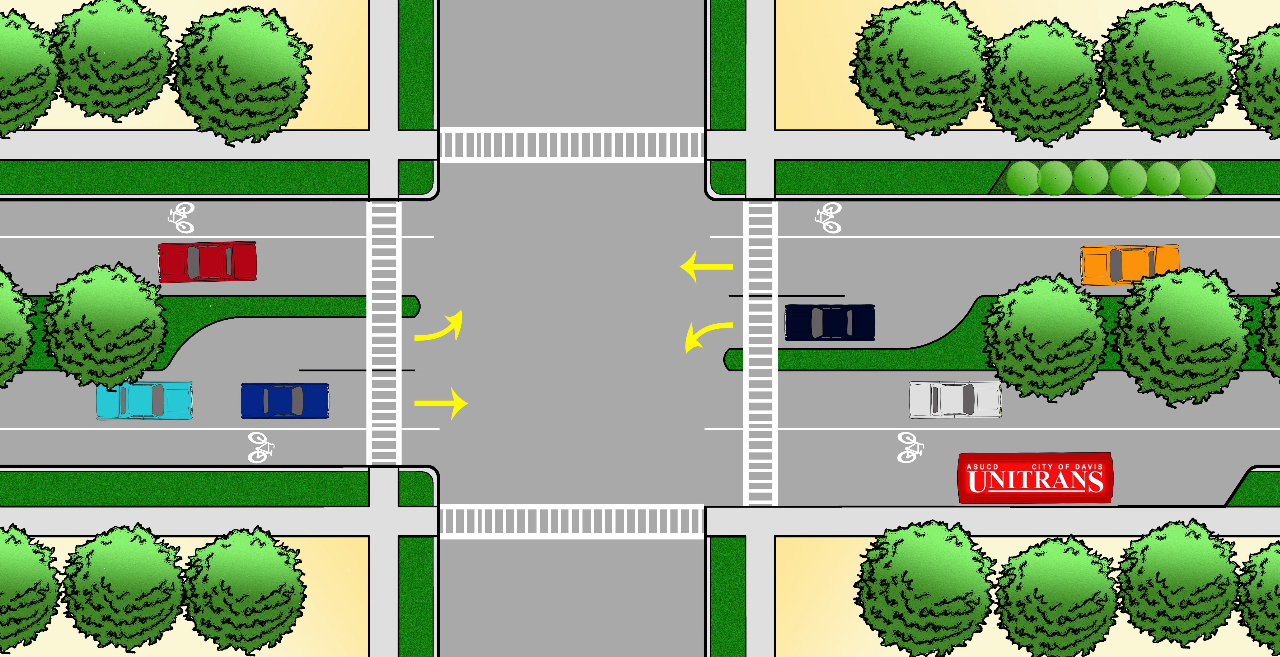
In September of 2009, the City Council endorsed a “road diet” to reduce the number of lanes on Fifth Street, according to Roxanne Namazi, a senior civil engineer and the project manager for the improvement. With a federal grant of $836,000, a revamp of Fifth Street is set to begin.
The city plans on providing separate left turn lanes, turn pockets, and bicycle lanes by making this popular route one lane each way as opposed to two. Namazi also said marked crosswalks, ramps and new traffic signals will be added. Trees will line the middle of the street, separating the two lanes of traffic.
Benefits and Disadvantages
Steve Tracy, a transportation planner who is involved in “Davis Bicycles!”, recognizes the project’s setbacks. These include the financial burden on the city, the “messy detours” and traffic delays it will cause, and even the long, bitter political battle the proposal ignited.
With many City Council and community members firmly choosing a side over the plan, a decision was hard to come by. “Even if the opponents eventually decide we were right and the redesigned street is an improvement, these wounds take time to heal,” Tracy said.
However, he believes the benefits greatly outweigh these issues. There will be fewer collisions because “the drivers’ field of play will be narrowed” to a single lane and impatient drivers will be forced “to follow behind prudent drivers who are obeying the law.” As a result, he believes bicycle and pedestrian safety will improve dramatically.
Additionally, two different traffic models, by the City’s consultant and the UC Davis Engineering School, have been created. The models illustrate that even with lower vehicle speeds, travel time for a round trip from A Street to L Street during rush hour will decrease because turning cars will not interfere with traffic.
“So what’s not to love? We have a street that reduces travel time, while at the same time makes the journey much less hazardous for motorists,” Tracy said.
Fifth Street and DHS
On a normal drive down Fifth Street to DHS in the morning, many cars hustle through town trying to avoid the red lights on F Street and G Street.
12…11…10………2…1…The timer on the crosswalk lets you judge whether you will make it through or need to step on it (the gas or the brake, you decide).
It’s a race to get through in a timely manner. And when you’re running late, a 29-car train is sure to make you a truant at DHS.
When sophomores Kendra Flin and Tsetsen Anuurad bike to DHS from South Davis, they take Pole Line to Fifth Street. However, when they reach L Street and see the commotion of careless cars ahead, they opt for “less traffic and cars as possible, so we take more remote streets,” Anuurad said.
Patsy Eubanks Owens, a professor and chair of the Department of Environmental Design at UCD, took part in the Healthy Youth/Healthy Regions project at the university. The youth she interviewed had similar reactions regarding the experience of traveling to school. They “expressed a desire to have transportation options that were pleasant experiences,” Eubanks Owens said. In other words, having heavy traffic close by was not what they wanted.
From her informal observations and knowledge, Eubanks Owens believes 8th Street and 14th Street are the more frequently used “east-west corridors” for school routes.
Students who live in South Davis, however, have a more complicated route in order to avoid Fifth Street. “It would be faster if I didn’t have to go around but could use Fifth,” Flin said.
Bikers may push for a quicker, more direct way to school, but students who drive to DHS have concerns too. Senior Kimberly Robertson fears a congested one-lane could lead to delays. She also rides her bike to school sometimes, so she knows how it is from the other side too. Biking from South Davis, she takes the bike loop. Though she believes Fifth Street would be faster, she simply does not want to deal with cars.
Tracy’s opinion and hopes are clear. “This is part of a movement for a makeover of many of our streets in Davis to make our pedestrian and bicycling environments safer so more students can leave the car at home and GET ON YOUR BIKES! I mean it!” Tracy said.